

The Faroes is a fascinating and varied place to hike, a strange archipelago of 18 islands to explore and uncover. Far flung out in the North Atlantic, they offer all manner of wet, windy and wild adventures.
We spent a week there in June having just that, and doing as many of the walks in the Visit Faroe Islands online hiking guide as we could. We’ve returned with our top 3.
We’ve chosen these as our favourite day hikes on the Faroe Islands because they can all be:
- Completed in a day (or substantially less)
- Are not too difficult
- Are free
- Take in some of the most famous parts of the Faroes (we’re firm believers in seeing popular places on foot for the best experience)
- And were just pretty damn enjoyable.
We’ve given brief descriptions of each walk and GPX files to download. But we’d recommend downloading the free Visit Faroes hiking guide we used for specific directions. All of these walks are in there except #3 – we did this ourselves following clear waymarks.

One more thing: they are all linear walks, so there’s some discussion to be had about how to get back. We talk a bit about this in our post everything you need to know about hiking on the Faroes but our own experience tended to be simply walking out, then walking back. It’s time-consuming but ultimately pretty doable.
READ: Everything you need to know about hiking on the Faroes
Note: we were supported on our trip to the Faroe Islands by Visit Faroe Islands, who offered us flights and accommodation to experience the hiking for ourselves. All of our blog posts are our honest experiences of what we found and liked.
3 DAY HIKES ON THE FAROE ISLANDS
To Gásadalur, on the island of Vágar
DISTANCE: 4km (one way)
GOOD FOR: seeing the famous Múlafossur waterfall and Drangarnir sea stacks
AMENITIES: a café at Gásadalur
Route map here and message below for GPX file
A beautiful walk to the old village of Gásadalur on which you will find yourself half musing on its romantic history, and half gasping for breath hauling yourself up one steep, steep hill. (Tbh, isn’t hiking always a mix of this?).
This trail winds up and over the giant hill of Gásadalsbrekkan, following cairns (piles of stones that mark the way instead of a traditional path). And it’s old: before the tunnel through the hill was built in 2004, this path was the only way in and out of Gásadalur. It’s called a ‘coffin route’ for chillingly literal reasons.

Yes, think of the pallbearers as you heave and huff up the first 1km of which is particularly steep. For the unencumbered walker it’s not all that bad, being mostly on grass (surely the best surface to walk on) and zig zagging up fairly steadily. Still, carrying a coffin seems categorically impossible.
Once at the top of the climb, you get afar views of the Drangarnir sea stacks, the monstrous rock formations that looks like some prehistoric animal rearing out of the sea.
The trail then flattens out to reach the other side of the hill, and begin descending to Gásadalur. It’s possible to get down to the sea waterfall Múlafossur too, probably the most famous on the Faroes.

Saksun to Tjørnuvik, on the island of Streymoy
DISTANCE: 6.5km (one way)
GOOD FOR: classic Faroese views, valleys and villages
AMENITIES: Toilets and a café either side of the walk
Message us for the GPX file and the route map is here
You will want to visit both these villages anyway, so why not walk between them? The walk traverses two plateaus with steep sections leading to both villages but is such an exciting adventure it became one of our favourite memories.
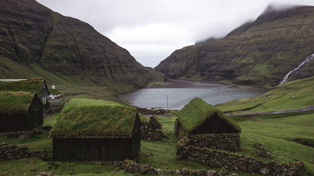
Saksun is an inland village complete with grass-rooved cottages, Faroese church and narrow tidal inlet out to sea. Tjørnuvik by contrast is a coastal community, set in the basin of a valley that opens directly out to the ocean, a black beach steadily biting out chunks of village, and the famous twin sea stacks of Risin og Kellingin ( the Giant and his Wife) in the distance.


It’s about 3 hours one way, and while not too difficult, has enough up and down to tire you out. But you will see and feel more of the Faroes doing this walk than many, many hours driving around in the car.
To Kallur Lighthouse, on the island of Kalsoy
DISTANCE: 1.75km (one way)
GOOD FOR: precipitous sea cliffs, quieter island
AMENITIES: toilet at the trailhead in Trøllanes
Send us a message below for GPX file and see map here
The only one of our chosen walks not in the Visit Faroe Islands hiking guide, the walk out to the Kallur lighthouse, perched on the northernmost finger of Kalsoy, is a pretty famous walk anyway and well worth it in our opinion.
It is a car ferry and a 30 minute drive to the trailhead, at the car park in the village of Trøllanes. From there it’s trekking over sheep fields steadily uphill until simply reaching the end of the land. The lighthouse teeters right at the edge. Look behind you and the cliff rears up over the lighthouse like a giant wave.

For detailed info, check out this excellent blog post by Andrew and Emily from Along Dusty Roads about getting to Kalsoy and the Kallur lighthouse.
BONUS HIKE
To see Trøllkonufingur, on the island of Streymoy
DISTANCE: 6.3km (one way)
GOOD FOR: Lunar landscapes, stunning fjord panoramas, the Trøllkonufingur
AMENITIES: none
Route map here and message us for GPX
Just missing the podium is the hike we did to see Trøllkonufingur, the jagged steeple of rock out at sea called the Troll Woman’s Finger.
This walk doesn’t actually go to Trøllkonufingur but instead offers a dramatic view of the finger from the other side of the channel.


It begins in a rubbly sort of car park and leads straight out into a lunar landscape that is pure Faroe Islands. We did this walk twice in vastly different conditions and both times were eerie and magical.
It’s another cairn-marked walk so clear weather would be needed. And it does begin and finish in slightly awkward, isolated places. Our recommendation would be to either walk it out and then back, or only walk the first half (the best half, seeing the Finger) and turn around.
Let us know what you think of these day hikes on the Faroe Islands below!
PIN IT:

Thanks very much for taking the time to create this blog for future travelers to the Faroes like me.
Thank you Gregory, hope you have a good trip. The Faroe Islands are a truly outstanding place to explore!
Nice write-up. Is there a practical way to hike Saksun to Tjørnuvik, or Gásadalur village for that matter, just one-way, and arrange for some kind of transportation for the return, rather than have to back-track?
Thanks.
Hope you managed to figure this out, Dave? Sorry for the delay, we’ve been offline. We couldn’t make public transport work for either!
Hey! Thanks for the post, however, Saksun is on the island Streymoy, not Eysturoy 🙂
Thank you! Updated! Sorry for the delay in replying, we’ve been offline!
Luke