

We didn’t know much about Brothers’ Point on Skye the first time we visited the island. It was only after some digging and exploring that we ended up, much later, at the trailhead one early morning, and went on a perfect sunrise adventure full of surprises.
Brothers’ Point (Rubha nam Brathairean in Gaelic) is a headland jutting out into the Atlantic Ocean with its own long history. The name is said to be from a monastic community founded here. But there’s much, much older remains here too. As of last year, dinosaur footprints have been found at Brothers’ Point, made over 170 million years ago. They’re from dinosaurs called sauropods (hence the post name eh?). Woah there.
To stand on this wild and windy edge of the world, you’ll have one foot in the present, one in the past.


- START: layby at Culnacnoc
- FINISH: Brothers’ Point headland
- TIME: 2 hours
- DISTANCE: 3.5km
Brothers’ Point, Skye hike | Route notes
The walk itself is a fairly simply out-and-back, and like this Quiraing hike, absolutely perfect for sunrise. It’s also a great spot for wildlife watching of the less Jurassic variety (did we see anything? Of course not, but still.)

From the layby at Culnacnoc walk south along the road for around 100m. Then take a turn left onto a rough track down a narrow gorge heading towards the coast.
Go through a gate, turn right and continue down onto a grassy footpath. After a short while, you’ll reach the shore, a rocky beach strewn with huge knobbly pebbles. Turn right and pick your way through. It’s alright, you can follow sheep trails along the coastline and the path becomes clearer the further along you walk.
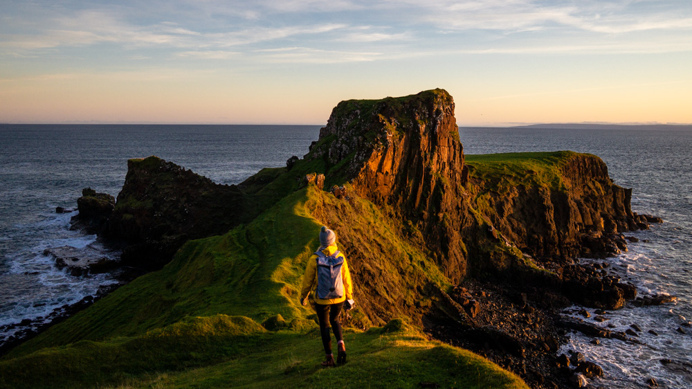
After a bit, you ascend and the peninsula of Brothers’ Point, Skye comes into view. The path is now obvious, but narrow along the cliff edge.
Soon you’ll reach a flattish area and a stile. Look beyond and there are incredible views south along the coastline of Skye. Squint and you can make out the Old Man of Storr peaking over the rock cliffs.

Walk down onto the peninsula to explore Brothers’ Point itself. It’s perfectly fine to get up to the highest point of the peninsula – just follow a steep little path up onto it. This hill is called Dun Hasan, and there used to be a medieval fort here.
Walk out right to the end of the peninsula. There’s a flat plateau beyond the Dun Hasan, almost like a field, weirdly. Right at the edge most likely it’ll be windy, with the waves crashing around below chaotically. But if you do get there for sunrise, you might be lucky and see it in pinky golden calm. Keep a look out for those whales and dolphins. Then, return the way you came.
Let us know if you’ve been on the Brothers’ Point walk in the comments – we’ll be adding our dinosaur findings soon.
Pin it:

The point is absolutely gorgeous in the morning sun. Your photos are the first ones I’ve seen of Brothers Point at that time of day and it looks just magical.
We’re going to be in Skye for a couple of days and not sure we’ll be able to do all these stunning walks. I’d love to squeeze this one in, but then there is Quiraing and the Old Man of Storr as well. Would you say that Brothers Point is worth doing over either of the other two?
Hi Matt,
Brothers’ Point is not as important to do as The Old Man of Storr and Quiraing. But it is a magical little hike. And all three are perfect at dawn and in the morning, so if you only have a couple of days you can only really do two at the best time of day. Bearing in mind that Skye weather isn’t great most of the time, you could get away with doing the Old man or Quiraing later in the day when the clouds are whirling around and making it very atmospheric. So you could do Brothers’ Point followed by The Old Man of Storr on one day and then do the Quiraing walk the other day, followed by a little stroll in the Fairy Glen which isn’t too far away.
Hope this helps!
Luke
Hey Luke,
Thanks for that insight, I appreciate it! We’ve got time definitely for two with a bit of buffer time for bad weather, the third is a maybe depending on weather. It’s difficult to pick which two to prioritise thouh. I think we can make all three work if we get good weather… If… 🙂
I think we’ll focus on definitely doing Storr and Quiraing, that’s the conclusion we were already leaning towards, and then if the weather and time works, do Brother’s Point.
Thanks again for your thoughts!