

No, it’s not dream, you’re just on the Isle of Skye. More particularly on the Quiraing hike on the Isle of Skye, wandering through one of the most spectacular and unreal landscapes in the world.
- START: Quiraing car park
- FINISH: Quiraing car park
- TIME: 3 hours
- DISTANCE: 6km
- View our map of the Quiraing hike here
When we decided to base ourselves for a time on the Isle of Skye, Scotland, we knew we were stepping into a dream of some peculiar sort. Skye’s landscapes are so wonderfully weird: few trees or houses, it’s battered by storms and carved of ice.
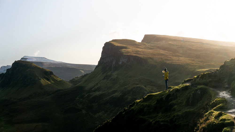
And nowhere is this more apparent than here, on the Quiraing hike. It traverses the most spectacular part of the Trotternish Ridge, Skye’s hulking rocky landslip spine. From it there are ginormous views of the craggy landscape, the Atlantic Ocean, the islands of Raasay and Rona, and the mainland of Scotland.
It’s one of the first places on Skye we hiked that had our jaws on the floor.

And this path has a few more pluses: it’s short, fairly easy, and a loop so you conveniently end up back where you started (the car park). And even though the Trotternish Ridge and the Quiraing is once of the most popular parts of Skye, we found that even in the busy summer season once we’d set out along the route it was serenity itself.
And finally: it’s perfect for sunrise, the sun arriving directly in front of you as you walk.
The Quiraing hike | route notes
Begin at the car park. There’s already mighty beautiful views here, and you could follow our previous suggestion to find a good Quiraing viewpoint here, but to begin this particular Quiraing hike, walk to the left along the hillside, probably accompanied by a fair few aimless tourists (but not for that long).
After 1km or so, you’ll come to small gully with a stream, which you carefully crossed (it’s fairly simple but don’t worry, this is the only time you have to do this. Will probably put off the tourists though!).
Continue along the narrow hillside path – breathtaking views a constant companion – for another 500m, as you ascend into heart of the Quiraing.

At the top: our favorite part
At top of the climb where path turns to the left, you’ll arrive at the ‘must-see’ points: the ‘Prison’ up on your right (it looks like a fortress from a certain angle), the ‘Needle’ to the left (a tall spindle of rock) and behind which is the ‘Table’ (a flat tabletop appearance).
Continue on the clear path, contouring along the landslip side below Trotternish Ridge, heading north.
You’ll soon enter into a strange, rocky, deserted glen, skirting a lochan (a little loch!). When we hiked this we were completely alone, passing cairns made from the landslip rubble.

Climb up to the left to a ridge that looks like a dinosaur back, called Sron Vourlin.
At the crest of the ridge turn to the left and climb up a steady slope – you’re now actually on top of the Trotternish Ridge, which is rather cool.


When you get up to the summit, you’ll arrive out onto a wide open plateau. You can see The Table if you look over the edge.
Continue to walk across plateau, looking out along length of Skye and across to Torridon on mainland Scotland.
You could end the Quiraing hike right here, turning back and retracing your steps. But a quicker -if less easy- way is to cut down the hill, following the faint path back down to the Quiraing car park, which you’ll see below you.

A note though: this was quite boggy and steep and would be particularly tricky in wet weather.
And then you’re back to where you started. If you’ve been there for sunrise (and we’d completely recommend you do) it’s a perfect time to go get some breakfast.
Let us know if you did this hike below in the comments!
Pin it:

Wow! I’m so happy I found your blog. I have a walker’s soul as well but have been utilizing too much on the urban landscapes. Nice aswell but nothing compares to nature.
Completely agree – well said!
What time do you suggest getting out on this trail? sunrise (when I’m visiting is 4:30am :))
I would LOVE to beat all the tourists but curious when you think people really get going for the day?
Hi Lindsay, sorry for delay in getting back to you. You’ll be ahead of most people if you’re striding out on the walk at 8am. We used to found it got busier after 10am. Enjoy!
The Quiraing is the most spectacular site imaginable. There are stunning views every where you turn. I stayed the night before in Staffin, with a view of The Quirang and I just stood there before dark, watching the peaks appear and disappear as clouds past by. At first light I set out for the car park, about twenty minutes away. Words cannot adequately just how big and amazing it is. I took lots of great scenic shots. It is a “must see”.
Agreed, Peter, it really lives up to its reputation. It really is otherworldly! The longer walk, even though not long, which many visitors don’t have time to do is so, so good. It’s a shame so many miss out on it. Glad you made the most of it though!